Ymele:Map for the Silesian and Seven Years Wars.jpg

Micelness þisre forebysene: 800 be 592 dotta. Oðra metinga brædo: 320 be 237 dotta | 640 be 474 dotta | 1,024 be 758 dotta | 1,280 be 948 dotta | 1,672 be 1,238 dotta.
Frumlicu ymele (1,672 × 1,238 pixela, ymelan micelness: 438 KB, MIME cynn: image/jpeg)
Scortness
| Towritenness |
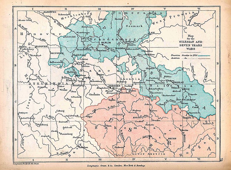
English: A map of Central Europe depicting the principal regions of conflict in the Silesian Wars of the 1740s–60s. The blue and red regions highlight Prussian and Austrian territory (respectively) as of 1756. |
| Tælmearc | |
| Fruma | The map is taken from "The Public Schools Historical Atlas" by Charles Colbeck. Longmans, Green, & Co.: New York; London; Bombay. 1905. It was accessed through the University of Texas at Austin's Perry-Castañeda Library Map Collection. The original map comes from "Frederick the Great and the Seven Years' War" by Frederick William Longman (1881). |
| Dædfruma |
Frederick William Longman Charles Colbeck (editor) |
Leaf:
|
The author died in 1908, so this work is in the public domain in its country of origin and other countries and areas where the copyright term is the author's life plus 100 years or fewer. This work is in the public domain in the United States because it was published (or registered with the U.S. Copyright Office) before January 1, 1929. | |
| This file has been identified as being free of known restrictions under copyright law, including all related and neighboring rights. | |
Ymelan stær
Swing dæg/tide mid mys to seonne þa ymelan swa heo wæs on þære tide geywed.
| Dæg/Tid | Metungincel | Micelnesse gemetu | Brucend | Ymbspræc | |
|---|---|---|---|---|---|
| nu | 12:25, 7 Winterfylleð 2019 | | 1,672 × 1,238 (438 KB) | Soerfm | Contrast |
| 17:42, 7 Se Æfterra Gēola 2019 |  | 1,672 × 1,238 (338 KB) | Bryanrutherford0 | User created page with UploadWizard |
Biliþbendas
Þǣr sind nāne trametas þe bindaþ tō þissum biliðe.